EMODnet Product Catalogue
0.000130208334 degree
Type of resources
Available actions
Topics
Keywords
Contact for the resource
Provided by
Years
Formats
Scale 1:
Resolution
-

Description of measurements/samples, purpose for which they were collected, and the platforms/instrumentation and methods in collection RV Celtic Voyager 2021 Legs Celtic Sea 14m Globe composite DTM WGS 1984 projection Lowest Astronomical Tide (LAT). The GSI has been permitted to utilise the UKHO VORF (Vertical Offshore Reference Frame) sea surface model. This model allows the use of ‘GPS tides’ and the GSI has gridded this model to a 1km resolution around Ireland to 15km offshore for reducing all soundings to Lowest Astronomical Tide - LAT (VORF). By utilising ‘GPS tides’ there is no requirement to adjust for draft or squat as the water level is modelled over the seabed as measured to the WGS84 ellipsoid. This area was surveyed as part of the ongoing INFOMAR project (formerly Irish National Seabed Survey), a joint seabed mapping project between the Geological Survey Ireland and the Marine Institute. Survey work was conducted to standards and recommendations set out by INFOMAR, the International Hydrographic Organisation (IHO), the United Kingdom Hydrographic Office (UKHO) and the UK’s Maritime and Coastguard Agency (MCA). Please note the following: Data acquired prior to March 2011 were levelled to Lowest Astronomical Tide (LAT) using shifts derived from Proudman Oceanographic tidal model. Tidal height was derived using a network of offshore and onshore tide gauges. As such data are on average 0.54m deeper than the more recent UKHO Vertical Offshore Reference Frame (VORF) levelled data. We are currently updating the older datasets. Statement on the level of data processed and quality control, limitations on reliability INFOMAR bathymetry products generated to meet International Hydrographic Organization (IHO) standards to ensure gridded data positional accuracy in the horizontal (XY) and vertical (Z) frame. Arrangement of data Data has been processed and arranged into a GLOBE DTM grid using XYZ data. Spatial and temporal resolution of data within the dataset Image resolution is a 14m DTM grid. Length of time series Image created from data collected between 2021-07-01 and 2021-09-21 Amount of data expressed in number of stations, sites, observations, cores, months of recordings, miles of track or other units as appropriate Bathymetry image meets GLOBE DTM standard. Data provided under Creative Commons licence access and use conditions. Users of this data should provide the following attribution statement “Contains Irish Public Sector Data (Geological Survey Ireland; Marine Institute) licensed under a Creative Commons Attribution 4.0 International (CC BY 4.0) licence”
-
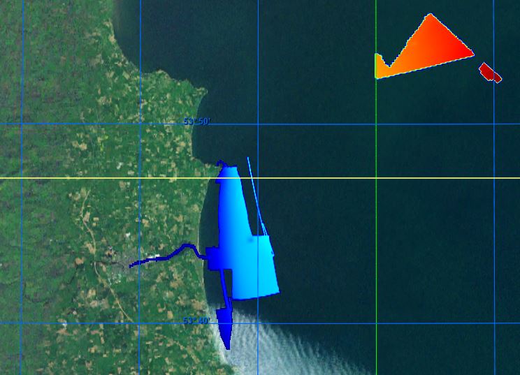
Description of measurements/samples, purpose for which they were collected, and the platforms/instrumentation and methods in collection GEO15_04 Irish Sea Drogheda 14m Globe DTM WGS 1984 projection Lowest Astronomical Tide (LAT). The GSI has been permitted to utilise the UKHO VORF (Vertical Offshore Reference Frame) sea surface model. This model allows the use of ‘GPS tides’ and the GSI has gridded this model to a 1km resolution around Ireland to 15km offshore for reducing all soundings to Lowest Astronomical Tide - LAT (VORF). By utilising ‘GPS tides’ there is no requirement to adjust for draft or squat as the water level is modelled over the seabed as measured to the WGS84 ellipsoid. This area was surveyed as part of the ongoing INFOMAR project (formerly Irish National Seabed Survey), a joint seabed mapping project between the Geological Survey Ireland and the Marine Institute. Survey work was conducted to standards and recommendations set out by INFOMAR, the International Hydrographic Organisation (IHO), the United Kingdom Hydrographic Office (UKHO) and the UK’s Maritime and Coastguard Agency (MCA). Please note the following: Data acquired prior to March 2011 were levelled to Lowest Astronomical Tide (LAT) using shifts derived from Proudman Oceanographic tidal model. Tidal height was derived using a network of offshore and onshore tide gauges. As such data are on average 0.54m deeper than the more recent UKHO Vertical Offshore Reference Frame (VORF) levelled data. We are currently updating the older datasets. Statement on the level of data processed and quality control, limitations on reliability INFOMAR bathymetry products generated to meet International Hydrographic Organization (IHO) standards to ensure gridded data positional accuracy in the horizontal (XY) and vertical (Z) frame. Arrangement of data Data has been processed and arranged into a GLOBE DTM grid using XYZ data. Spatial and temporal resolution of data within the dataset Image resolution is a 14m DTM grid. Length of time series Image created from data collected between 2015-10-01 and 2015-10-20 Amount of data expressed in number of stations, sites, observations, cores, months of recordings, miles of track or other units as appropriate Bathymetry image meets GLOBE DTM standard. Data provided under Creative Commons licence access and use conditions. Users of this data should provide the following attribution statement "Contains Irish Public Sector Data (Geological Survey Ireland; Marine Institute) licensed under a Creative Commons Attribution 4.0 International (CC BY 4.0) licence"
-
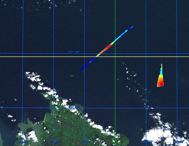
Description of measurements/samples, purpose for which they were collected, and the platforms/instrumentation and methods in collection RV Celtic Explorer 2019 Leg 1 Celtic Sea North Cork 14m Globe DTM WGS 1984 projection Lowest Astronomical Tide (LAT). The GSI has been permitted to utilise the UKHO VORF (Vertical Offshore Reference Frame) sea surface model. This model allows the use of ‘GPS tides’ and the GSI has gridded this model to a 1km resolution around Ireland to 15km offshore for reducing all soundings to Lowest Astronomical Tide - LAT (VORF). By utilising ‘GPS tides’ there is no requirement to adjust for draft or squat as the water level is modelled over the seabed as measured to the WGS84 ellipsoid. This area was surveyed as part of the ongoing INFOMAR project (formerly Irish National Seabed Survey), a joint seabed mapping project between the Geological Survey Ireland and the Marine Institute. Survey work was conducted to standards and recommendations set out by INFOMAR, the International Hydrographic Organisation (IHO), the United Kingdom Hydrographic Office (UKHO) and the UK’s Maritime and Coastguard Agency (MCA). Please note the following: Data acquired prior to March 2011 were levelled to Lowest Astronomical Tide (LAT) using shifts derived from Proudman Oceanographic tidal model. Tidal height was derived using a network of offshore and onshore tide gauges. As such data are on average 0.54m deeper than the more recent UKHO Vertical Offshore Reference Frame (VORF) levelled data. We are currently updating the older datasets. Statement on the level of data processed and quality control, limitations on reliability INFOMAR bathymetry products generated to meet International Hydrographic Organization (IHO) standards to ensure gridded data positional accuracy in the horizontal (XY) and vertical (Z) frame. Arrangement of data Data has been processed and arranged into a GLOBE DTM grid using XYZ data. Spatial and temporal resolution of data within the dataset Image resolution is a 14m DTM grid. Length of time series Image created from data collected between 2019-09-21 and 2019-10-08 Amount of data expressed in number of stations, sites, observations, cores, months of recordings, miles of track or other units as appropriate Bathymetry image meets GLOBE DTM standard. Data provided under Creative Commons licence access and use conditions. Users of this data should provide the following attribution statement “Contains Irish Public Sector Data (Geological Survey Ireland; Marine Institute) licensed under a Creative Commons Attribution 4.0 International (CC BY 4.0) licence”
-
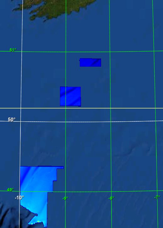
Description of measurements/samples, purpose for which they were collected, and the platforms/instrumentation and methods in collection RV Mallet 2019-2020 Legs Celtic Sea Cork 14m Globe DTM WGS 1984 projection Lowest Astronomical Tide (LAT). The GSI has been permitted to utilise the UKHO VORF (Vertical Offshore Reference Frame) sea surface model. This model allows the use of ‘GPS tides’ and the GSI has gridded this model to a 1km resolution around Ireland to 15km offshore for reducing all soundings to Lowest Astronomical Tide - LAT (VORF). By utilising ‘GPS tides’ there is no requirement to adjust for draft or squat as the water level is modelled over the seabed as measured to the WGS84 ellipsoid. This area was surveyed as part of the ongoing INFOMAR project (formerly Irish National Seabed Survey), a joint seabed mapping project between the Geological Survey Ireland and the Marine Institute. Survey work was conducted to standards and recommendations set out by INFOMAR, the International Hydrographic Organisation (IHO), the United Kingdom Hydrographic Office (UKHO) and the UK’s Maritime and Coastguard Agency (MCA). Please note the following: Data acquired prior to March 2011 were levelled to Lowest Astronomical Tide (LAT) using shifts derived from Proudman Oceanographic tidal model. Tidal height was derived using a network of offshore and onshore tide gauges. As such data are on average 0.54m deeper than the more recent UKHO Vertical Offshore Reference Frame (VORF) levelled data. We are currently updating the older datasets. Statement on the level of data processed and quality control, limitations on reliability INFOMAR bathymetry products generated to meet International Hydrographic Organization (IHO) standards to ensure gridded data positional accuracy in the horizontal (XY) and vertical (Z) frame. Arrangement of data Data has been processed and arranged into a GLOBE DTM grid using XYZ data. Spatial and temporal resolution of data within the dataset Image resolution is a 14m DTM grid. Length of time series Image created from data collected between 2019-07-17 and 2020-10-31 Amount of data expressed in number of stations, sites, observations, cores, months of recordings, miles of track or other units as appropriate Bathymetry image meets GLOBE DTM standard. Data provided under Creative Commons licence access and use conditions. Users of this data should provide the following attribution statement "Contains Irish Public Sector Data (INFOMAR, Geological Survey Ireland; Marine Institute) licensed under a Creative Commons Attribution 4.0 International (CC BY 4.0) licence"
-
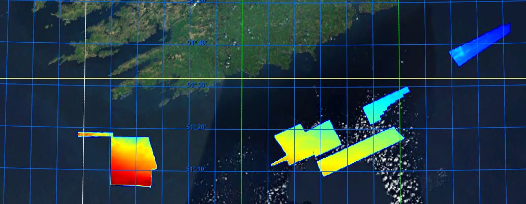
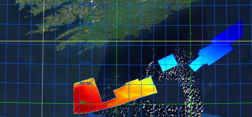
Description of measurements/samples, purpose for which they were collected, and the platforms/instrumentation and methods in collection RV Keary 2019 and 2020 legs Celtic Sea Cork 14m Globe DTM WGS 1984 projection Lowest Astronomical Tide (LAT). The GSI has been permitted to utilise the UKHO VORF (Vertical Offshore Reference Frame) sea surface model. This model allows the use of ‘GPS tides’ and the GSI has gridded this model to a 1km resolution around Ireland to 15km offshore for reducing all soundings to Lowest Astronomical Tide - LAT (VORF). By utilising ‘GPS tides’ there is no requirement to adjust for draft or squat as the water level is modelled over the seabed as measured to the WGS84 ellipsoid. This area was surveyed as part of the INFOMAR joint mapping project by the Geological Survey Ireland and the Marine Institute. Survey work was conducted to standards and recommendations set out by INFOMAR, the International Hydrographic Organisation (IHO), the United Kingdom Hydrographic Office (UKHO) and the UK’s Maritime and Coastguard Agency (MCA). Please note the following: Data acquired prior to March 2011 were levelled to Lowest Astronomical Tide (LAT) using shifts derived from Proudman Oceanographic tidal model. Tidal height was derived using a network of offshore and onshore tide gauges. As such data are on average 0.54m deeper than the more recent UKHO Vertical Offshore Reference Frame (VORF) levelled data. We are currently updating the older datasets. Statement on the level of data processed and quality control, limitations on reliability INFOMAR bathymetry products generated to meet International Hydrographic Organization (IHO) standards to ensure gridded data positional accuracy in the horizontal (XY) and vertical (Z) frame. Arrangement of data Data has been processed and arranged into a GLOBE DTM grid using XYZ data. Spatial and temporal resolution of data within the dataset Image resolution is a 14m DTM grid. Length of time series Image created from data collected between 2019-07 and 2020-10-17 Amount of data expressed in number of stations, sites, observations, cores, months of recordings, miles of track or other units as appropriate Bathymetry image meets GLOBE DTM standard. Data provided under Creative Commons licence access and use conditions. Users of this data should provide the following attribution statement "Contains Irish Public Sector Data (INFOMAR; Geological Survey Ireland; Marine Institute) licensed under a Creative Commons Attribution 4.0 International (CC BY 4.0) licence"
-
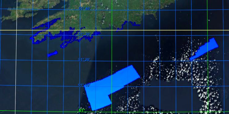
Description of measurements/samples, purpose for which they were collected, and the platforms/instrumentation and methods in collection GEO19_04 Celtic Sea Cork 14m Globe DTM WGS 1984 projection Lowest Astronomical Tide (LAT). The GSI has been permitted to utilise the UKHO VORF (Vertical Offshore Reference Frame) sea surface model. This model allows the use of ‘GPS tides’ and the GSI has gridded this model to a 1km resolution around Ireland to 15km offshore for reducing all soundings to Lowest Astronomical Tide - LAT (VORF). By utilising ‘GPS tides’ there is no requirement to adjust for draft or squat as the water level is modelled over the seabed as measured to the WGS84 ellipsoid. This area was surveyed as part of the ongoing INFOMAR project (formerly Irish National Seabed Survey), a joint seabed mapping project between the Geological Survey Ireland and the Marine Institute. Survey work was conducted to standards and recommendations set out by INFOMAR, the International Hydrographic Organisation (IHO), the United Kingdom Hydrographic Office (UKHO) and the UK’s Maritime and Coastguard Agency (MCA). Please note the following: Data acquired prior to March 2011 were levelled to Lowest Astronomical Tide (LAT) using shifts derived from Proudman Oceanographic tidal model. Tidal height was derived using a network of offshore and onshore tide gauges. As such data are on average 0.54m deeper than the more recent UKHO Vertical Offshore Reference Frame (VORF) levelled data. We are currently updating the older datasets. Statement on the level of data processed and quality control, limitations on reliability INFOMAR bathymetry products generated to meet International Hydrographic Organization (IHO) standards to ensure gridded data positional accuracy in the horizontal (XY) and vertical (Z) frame. Arrangement of data Data has been processed and arranged into a GLOBE DTM grid using XYZ data. Spatial and temporal resolution of data within the dataset Image resolution is a 14m DTM grid. Length of time series Image created from data collected between 2019-07-18 and 2019-08-20 Amount of data expressed in number of stations, sites, observations, cores, months of recordings, miles of track or other units as appropriate Bathymetry image meets GLOBE DTM standard. Data provided under Creative Commons licence access and use conditions. Users of this data should provide the following attribution statement "Contains Irish Public Sector Data (INFOMAR; Geological Survey Ireland; Marine Institute) licensed under a Creative Commons Attribution 4.0 International (CC BY 4.0) licence"
-
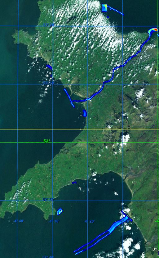
Description of measurements/samples, purpose for which they were collected, and the platforms/instrumentation and methods in collection RV Keary 2018 Leg 3 Irish Sea and St. George's Channel Anglesey Wales 14m Globe DTM WGS 1984 projection Lowest Astronomical Tide (LAT). The GSI has been permitted to utilise the UKHO VORF (Vertical Offshore Reference Frame) sea surface model. This model allows the use of ‘GPS tides’ and the GSI has gridded this model to a 1km resolution around Ireland to 15km offshore for reducing all soundings to Lowest Astronomical Tide - LAT (VORF). By utilising ‘GPS tides’ there is no requirement to adjust for draft or squat as the water level is modelled over the seabed as measured to the WGS84 ellipsoid. This area was surveyed as part of the ongoing CHERISH project by the Geological Survey Ireland. Survey work was conducted to standards and recommendations set out by INFOMAR, the International Hydrographic Organisation (IHO), the United Kingdom Hydrographic Office (UKHO) and the UK’s Maritime and Coastguard Agency (MCA). Please note the following: Data acquired prior to March 2011 were levelled to Lowest Astronomical Tide (LAT) using shifts derived from Proudman Oceanographic tidal model. Tidal height was derived using a network of offshore and onshore tide gauges. As such data are on average 0.54m deeper than the more recent UKHO Vertical Offshore Reference Frame (VORF) levelled data. We are currently updating the older datasets. Statement on the level of data processed and quality control, limitations on reliability INFOMAR bathymetry products generated to meet International Hydrographic Organization (IHO) standards to ensure gridded data positional accuracy in the horizontal (XY) and vertical (Z) frame. Arrangement of data Data has been processed and arranged into a GLOBE DTM grid using XYZ data. Spatial and temporal resolution of data within the dataset Image resolution is a 14m DTM grid. Length of time series Image created from data collected between 2018-06-26 and 2018-08-03 Amount of data expressed in number of stations, sites, observations, cores, months of recordings, miles of track or other units as appropriate Bathymetry image meets GLOBE DTM standard. Data provided under Creative Commons licence access and use conditions. Users of this data should provide the following attribution statement "Contains Irish Public Sector Data (CHERISH) licensed under a Creative Commons Attribution 4.0 International (CC BY 4.0) licence"
-